



Close Menu
Stratnews GlobalStratnews Global
    Facebook X (Twitter) Instagram
    Trending
    • Alibaba To Ban Employees From Using Anthropic’s Coding Tool
    • Meet The Robot That Walked Onto The FIFA World Cup Pitch
    • UN Chief Warns AI Is Outpacing Humanity
    • WhatsApp Username Feature: Anonymity Is A Weapon Of Mass Destruction
    • Embodied Intelligence Leads Beijing AI Showcase
    • India Questions Anonymous Messaging Features
    • Awais Ahmed: From Encyclopaedias to Space Startup
    • Can India Build Its Own EV Industrial Operating System?
    • Support Us
    Stratnews GlobalStratnews Global
    Write for Us
    Monday, July 6
    • Space
    • Science
    • AI and Robotics
    • Industry News
    • Support Us
    Stratnews GlobalStratnews Global
    Home » Pixxel Adds Three Satellites to Its Fleet, Expands Hyperspectral Earth Imaging Capabilities

    Pixxel Adds Three Satellites to Its Fleet, Expands Hyperspectral Earth Imaging Capabilities

    Huma SiddiquiBy Huma SiddiquiAugust 27, 2025Updated:August 27, 2025 India in Space No Comments2 Mins Read
    Pixxel

    Bengaluru-based space technology company Pixxel has expanded its satellite fleet with the successful launch of three additional hyperspectral imaging satellites aboard SpaceX’s NAOS mission on a Falcon 9 rocket. This brings its commercial Firefly constellation to a total of six satellites in orbit.

    This latest deployment follows the launch of Pixxel’s first three Firefly satellites earlier this year. With six operational satellites, the company now offers daily global coverage using hyperspectral imaging technology—an emerging remote sensing method that captures data across more than 135 spectral bands.

    Pixxel Satellites

    Each Firefly satellite is capable of imaging at 5-meter spatial resolution across a 40-kilometre swath, enabling the detection of subtle environmental and material changes on Earth’s surface. These capabilities are being used to monitor factors such as crop stress, pollution sources, and mineral compositions—many of which are difficult to detect using traditional imaging systems.

    Pixxel’s CEO Awais Ahmed said the latest launch marks a shift from limited coverage to consistent planetary-scale monitoring. “With six satellites in orbit, we move closer to continuous, global hyperspectral observation,” Ahmed said in a statement. “The aim is to measure what was previously invisible and enable data-driven decision-making for long-term environmental health.”

    Looking ahead, Pixxel is preparing for the launch of its next generation of satellites, referred to as “Honeybees.” These upcoming spacecraft are expected to expand the imaging range into short-wave infrared (SWIR) bands, which would increase both spectral depth and the number of applications, from climate monitoring to natural resource management.
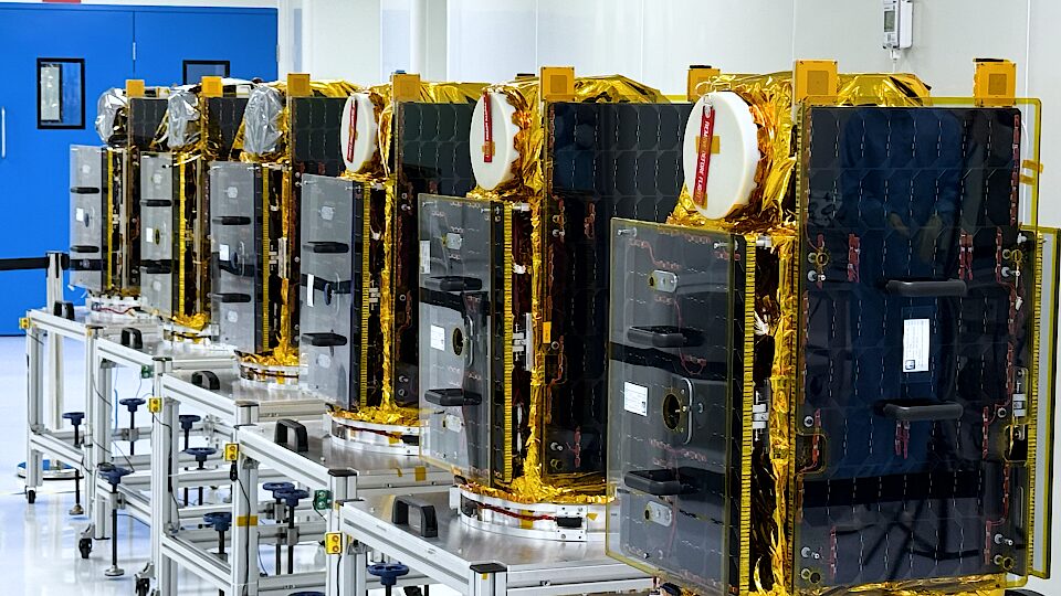
    Pixxel Satellites

    Pixxel’s Chief Technology Officer Kshitij Khandelwal noted that the company has now demonstrated its ability to not only deploy advanced imaging satellites but also scale them into a functioning commercial network. “The Firefly fleet has shown that hyperspectral imaging can be made operational at scale,” Khandelwal said. “The Honeybee series will further extend those capabilities.”

    The satellite constellation feeds data into its proprietary Aurora Earth Observation platform, which integrates artificial intelligence to help analyze and distribute insights across sectors. Pixxel is positioning its system to support predictive analytics for environmental monitoring and resource planning on a global scale.

    Author

    • Huma Siddiqui
      Huma Siddiqui
      View all posts
    Featured
    Share. Facebook Twitter Pinterest LinkedIn Tumblr Email Reddit Telegram WhatsApp
    Huma Siddiqui
    Huma Siddiqui

      Keep Reading

      Alibaba To Ban Employees From Using Anthropic’s Coding Tool

      Meet The Robot That Walked Onto The FIFA World Cup Pitch

      UN Chief Warns AI Is Outpacing Humanity

      WhatsApp Username Feature: Anonymity Is A Weapon Of Mass Destruction

      Embodied Intelligence Leads Beijing AI Showcase

      India Questions Anonymous Messaging Features

      Add A Comment
      Leave A Reply Cancel Reply

      Anti Drone System (CUAS)
      Latest Posts

      Alibaba To Ban Employees From Using Anthropic’s Coding Tool

      July 6, 2026

      Meet The Robot That Walked Onto The FIFA World Cup Pitch

      July 6, 2026

      UN Chief Warns AI Is Outpacing Humanity

      July 6, 2026

      WhatsApp Username Feature: Anonymity Is A Weapon Of Mass Destruction

      July 6, 2026

      Embodied Intelligence Leads Beijing AI Showcase

      July 3, 2026

      India Questions Anonymous Messaging Features

      July 3, 2026

      Awais Ahmed: From Encyclopaedias to Space Startup

      July 2, 2026

      Can India Build Its Own EV Industrial Operating System?

      July 2, 2026

      AI Fighter Jet: Flying Wedge Unveils FWD Supreme

      July 2, 2026

      Wayve Autonomous Driving AI Gains Investor Support

      July 2, 2026

      Subscribe to News

      Get the latest sports news from NewsSite about world, sports and politics.

      • Astronomical Events
      • Space Missions
      • Industry News
      • Science
      StratNewsGlobal Tech
      Facebook X (Twitter) Instagram LinkedIn YouTube
      © 2026 StratNews Global, A unit of BharatShakti Communications LLP
      • About Us
      • Contributors
      • Copyright
      • Contact
      • Write for Us

      Type above and press Enter to search. Press Esc to cancel.